Sunday, August 28, 2016

Travel Tip #47 - Preparing for a Backpacking Trip

     To someone who has been backpacking before, this tip is obvious. However, even an experienced backpacker usually ends up taking too much stuff on backpacking trips. What seems essential while you're sitting in your living room packing your pack may not seem so essential as you're lugging your 40 lb. pack up the side of a mountain. So here are some tips to consider when packing for a backpacking trip.
     1. Get a sturdy, lightweight pack. When I was a boy scout, all backpack were large, clunky, and had external metal-framed. In recent years, the much preferred backpack is more compact with a sturdy, yet lightweight internal frame. Not only are they better balanced, but they force you to pack lighter - which is essential for a successful trip.
     2. Remember the 10 essentials. According to Mountaineering: The Freedom of the Hills, there are ten essentials that any backpacker needs access to in order to have a fun, safe hike. Other organizations, such as the Boy Scouts, have adopted the list. The revised 2003 edition of the list identifies the 10 essentials as: Navigation, Sun Protection, Insulation, Illumination, First Aid supplies, Fire, Repair Kit and Tools, Nutrition, Hydration, and Emergency Shelter. For more detailed information on the 10 essentials, I'd encourage you to check out the following checklist.
     3. After the 10 essentials, bring only the bare necessities. When packing clothes, your main goal is to stay warm and protected from the sun. You don't want to bring an outfit for every day; rather, you will want a spare set of dry clothes to change into if they get wet. Other than that , try to reuse what you have. When packing food, plan your meals beforehand, relying heavily on lightweight dehydrated food. If you plan on fishing for your meals, make sure you have enough nourishment to get by in case you don't catch any fish. Remember, you don't need to eat like kings; eating like peasants will do. If you will be hiking where there are plenty of streams, don't carry enough water to last the whole trip; rather, carry enough for a day, and bring a lightweight water purifier to refill your bottles. (Just make sure you know how to use it ahead of time). Know how much fuel will need in order to boil water and cook your meals, so that you bring enough, but not too much. Let nature be your entertainment. The last thing you want to do is lug around unnecessary weight. A good rule of thumb is: If you can't decide whether or not you'll need it, you probably will not need it.
     4. For a long trip, it is worth the extra money to get lightweight equipment. Usually, I tend to buy things in bulk because they are cheaper. However, when backpacking, smaller, lightweight items are often worth every dollar. This principle is most easily applied when preparing toiletries - buy travel sizes. But it also applies to tents, sleeping bags, cameras, clothing, food, and fuel. I know hikers who cut the handle off of their toothbrushes to cut weight. After eight hours of carrying a pack, you will realize that every ounce counts.
     5. Be familiar with your map/navigation system. The last thing you want to do is get lost. That's how you die. So make sure you can use your navigation system. You also need to know how far apart water sources are so that you can carry enough water to get you from one source to the next. Also, make sure that someone else, who's not in your group, knows your route so that if you don't come home at the appropriate time, they can send help.
     For more ideas on how to prepare, you might want to check out this site. Have fun and be safe!

Sunday, August 21, 2016

Spotlight: Sierra Nevada Mountains - Sequoia National Park

Spotlight: Sequoia National Park is named for the Giant Sequoia tree which is only native to the western slopes of the Sierra Nevada Mountains. Sequoia trees are the world's largest living organism by volume. On average, they grow to between 164 and 279 feet high, with a record of 311 feet. The widest known sequoia (at chest height) measures 27 feet in diameter. The oldest known giant sequoia (based on ring count) was 3,500 years old. To protect these giants, Sequoia National Park was established on Sept. 25, 1890, and spans 404,064 acres, including Mount Whitney, the highest point in the continental United States.
     The Monachee Native Americans inhabited the area prior to the arrival of European settlers. They left many pictographs at several sites within the park, most notably at Hospital Rock. Unfortunately, the native population was decimated by small pox. The first European homesteader within the park's boundaries was Hale Tharp, who famously carved his home out of a fallen Sequoia tree. Tharp's Log can still be visited today in the same location in the Giant Forest. The Kaweah Colony attempted to derive economic success by harvesting lumber from the Giant Sequoias. Thousands of trees were chopped down before they realized that Sequoia wood wasn't suited for building since it splintered easily. Logging operations ceased completely after the national park was established.
     There is a wide variety of wildlife within the park's boundaries including: coyote, badger, black bearsheepdeerfoxcougar, woodpecker, turtles, owlsopossum, various species of snakewolverineroadrunnerbeaverfrogs, and muskrat.

Location: Sequoia National Park is located in the Sierra Nevada Mountains about six miles east of the town of Three Rivers.

Cost: $30/vehicle, $20/motorscycle or $15/individual for a week-long pass which is also good for Kings Canyon; free entry with the America the Beautiful National Parks Pass.
     Tickets to Crystal Cave are $16/adult, $8/youth (6-12), and $5/child (0-5).

Time: Sequoia and Kings Canyon are open 24 hours/day, 365 days/year weather permitting. Plan on spending between 2-7 days exploring the parks.

Description: The Giant Forest in Sequoia National Park is arguably the best sequoia grove on Earth. It is home to 5 of the 10 largest trees on Earth, including the General Sherman - the largest living tree on the planet. The Big Trees Trail is designed to be an easy hike for families and is wheelchair accessible.
     The Moro Rock to Crescent Meadow Road leads to several key attractions including Moro Rock, Tunnel Log, and the High Sierra Trail.
    Cedar Grove lies in one of the deepest canyons in the country. This grove is generally warmer, and thus doesn't have any giant sequoias; but it is the starting point for many backcountry trails. A rustic Visitor Center issues wilderness permits to visit these remote areas.
Hiking in the back country

     Mineral King Valley is the highest place accessible to park visitors and is reached via a steep, windy road that leads to high elevation wilderness areas. Be prepared because there is no gasoline or electricity in the valley. It is only open from late May to October.
     Crystal Cave is run by the Sequoia Parks Conservancy. It offers several tours including: The Family Tour, Early Bird Tour, Discovery Tour, Wild Cave Tour, Junior Caver Tour, and Halloween at Crystal Cave.
     The Generals Highway connects Sequoia NP with Kings Canyon NP. The Grant Tree Trail in Grant Grove in Kings Canyon NP leads to the General Grant, the second largest tree in the world, as well as many other beautiful giants. It also offers gorgeous vistas deep into the park's wilderness area.
Hamilton Lake
     Here are some photos of Sequoia's beautiful back country including Hamilton Lake and Precipice Lake:
Nothing like a cold, refreshing swim after hiking all day


Precipice Lake


Rating: 5 stars (out of 5)

Things You Should Know: - There is a difference between Sequoia National Forest and Sequoia National Park. Although both are beautiful, most visitors are looking for Sequoia NP, so plan accordingly.
- Over 80% of the parks is designated as wilderness area. You must obtain a wilderness permit if you stay overnight in these areas, which are only accessible on foot or horseback.
- Shuttles are a great way to explore the park while cutting down the pollution that is affecting these gentle giants. The Sequoia Shuttle can be accessed from Visalia or Three Rivers, and runs from May - September for $15/person (which includes park admission). There is also a free in park shuttle from Giant Forest Museum to Dorst Campground, and within the Lodgepole and Giant Forest areas.
- There are several Visitor Centers throughout the park that can help you make the most of your visit.
- There are plenty of camping, lodging, and restaurants in or around both national parks. However, campsites are difficult to get on summer and holiday weekends.
- Snow and ice are common on national park roads from early fall until late spring, so be prepared with tire chains if you are visiting during this period.
- Crystal Cave opens annually in May. Tickets must be purchased online and are not available at the cave entrance.
- Bears are active year-round in the park. You will need to store food and scented items in bear boxes so that they can't break in and get them.
Bear Country
- Several advisories are in effect for vehicles over 22 feet in length since they pose a danger on narrow, windy roads.

Nearby: Mount Whitney, Kings Canyon National Park, Yosemite National Park, Death Valley National Park

Sunday, August 14, 2016

Spotlight: Sierra Nevada Mountains - Devil's Postpile National Monument

Spotlight: Devil's Postpile National Monument was originally part of Yosemite National Park. However, the discovery of gold in the Mammoth Lakes area prompted a boundary change, leaving the formation on public land. When a proposal for a dam would have resulted in the postpile being blasted, John Muir and other influential Californians petitioned the federal government to stop the blasting, which resulted in the establishment of the National Monument in 1911. It protects the Devil's Postpile formation, the 101-foot tall Rainbow Falls, and 798 acres of pristine alpine forest.

     The formation is a rare example of columnar basalt which raises 60 feet high and portrays a unique symmetry. It was created after a volcano spewed lava into the Reds Meadow Valley creating a lava lake less than 100,000 years ago. As the lake cooled, it began to contract and crack into columns. The columns were originally much taller than they are today, but erosion over tens of thousands of years, particularly glacial activity, has diminished their size - as evidenced by the huge pile of broken rocks at the base of the formation. It was the glaciers, however, which uncovered the formation in the first place.
Broken fragments
     The monument is also a popular portal to the John Muir Trail. Many backpackers either start or end their excursion here where the tram offers easy access to and from civilization.

Location: Devil's Postpile NM is in the Sierra National Forest several miles east of Mammoth.

Cost: Shuttle bus fees are: $7/adult, $4/child (3-15); 3-day passes are available for double the price. Day passes cost $10/vehicle. Campsites cost $20/night.

Time: Devil's Postpile is only open to tourists from mid-June to late October, depending on weather conditions which may close the road in or out of the valley. During the summer season, the monument and campground are open 24/7. The Ranger station is open from 9am-5pm. You will probably want 4-6 hours to explore the monument.

Description: The Postpile is one of the most unique rock formations I've ever seen. The slow, even cooling of the lava lake allowed the jointing (rock splits) to occur in a relatively even pattern. If you take the trail up to the top, you can see that many of the basalt columns all have the same hexagonal shape, averaging 2 feet in diameter and 60 feet high. A survey showed that 44.5% are six-sided, 37.5 are 37.5% are five-sided, with the remainder 4-sided, 7-sided, or 3-sided. This is a higher percentage of hexagonal columns of any other known formation. Another unique feature is the lack of horizontal jointing. Furthermore, they have a polished shine to them due to glacial activity.


View of the tops of the pillars
     The other popular feature of the monument is Rainbow Falls. The Falls are 101 feet tall - the tallest waterfall along the San Joaquin River. The waterfall got its name from the rainbows that appear in its mist on sunny summer days. (Unfortunately, I don't have a digital photo of them.)

Rating:  4 stars (out of 5)

Things You Should Know: - The Shuttle Bus operates from 7am-7pm and is mandatory for travel through the monument during hours of operation. To view more information on fees and exceptions, click here.
- Popular activities at the monument include: hiking, fishing, camping, backpacking, horseback riding, photography and picnics. Some activities require permits.
- Keep an eye out for wildlife. We saw this coyote while waiting for the tram.

- Camping is first come, first serve - you cannot make reservations. Sites include flush toilets, picnic tables, a fire pit and bear-proof lockers. Pets are allowed in the campground, but must remain on a leash.
- During the winter months, the only access to the monument is via skis or snowshoes.
- Hikers may park in the overnight hiker parking lot located just outside the monument boundary. Shuttle bus users should leave their cars in the shuttle bus parking area located Mammoth Mountain Main Lodge.

Nearby: Mammoth Mountain Ski Resort, Whitmore Hot Springs, Mono Lake, Yosemite National Park

Sunday, August 7, 2016

Spotlight: Sierra Nevada Mountains - The John Muir Trail

Spotlight: The John Muir Trail is named after naturalist John Muir, who founded the Sierra Club and was instrumental in influencing the government to protect large tracts of land including Yosemite Valley and Sequoia National Park. His efforts to lobby for a National Parks system earned him the nickname "Father of the National Parks."
     The John Muir Trail is a 210-mile trail that connects two of his favorite places - Yosemite National Park and the peak of Mount Whitney (14,505 feet / 4421 meters). Construction of the trail began in 1915, a year after John Muir's death. About 160 miles of the trail follows the longer Pacific Crest Trail. Almost the entire trail traverses through the High Sierra backcountry, isolated from the huge crowds that jam the cities and freeways down in the valleys below. The vast majority of the trail lies at an elevation of 8,000+ feet (2,400 meters), including the final third of the trail which rises over 10,000 feet (3,000+ meters). Although it is arguably the most famous trail in the United States, it averages only about 1,500 through hikers each year - significantly less than the comparable Appalachian Trail in the East.

Location: The John Muir Trail starts at the Happy Isles Bridge in Yosemite National Park and traverses 210.4 miles of wilderness including Sequoia National Park and King's Canyon N.P. before ending on the  summit of Mount Whitney, the highest peak in the continental United States.

Cost: Depends on how much you need to spend to get outfitted for the trip with lightweight gear.

Time: 4 days to a month, depending on how much of the trail you decide to do in one shot. The primary hiking season is from July - September when most of the trail is free of snow.

Description: The trailhead for the John Muir Trail is Happy Isles Bridge in Yosemite National Park. However, if you don't intend to walk the entire 210-mile trail, you can access it from various starting points along the route. Since it takes about 30 days of steady hiking to traverse the entire route, most hikers take it in segments. We accessed the Trail from the Silver Lake campground (north of Mammoth Lakes) and hiked until Devil's Postpile National Monument. Although we intended to hike further, my hiking companion aggravated a knee injury necessitating our early exit. Still, we saw some amazing sites along the way.
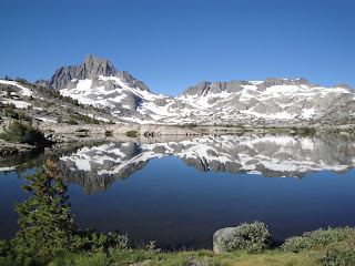
     On the first morning, we started from the Silver Lake Campground and hiked southwest toward Gem Lake. Along the way we saw a beautiful waterfall along Rush Creek, some insanely steep railroad tracks, and the magnificent cascades of Rush Creek as the waters plummeted from Gem Lake Dam down toward Agnew Lake. From Gem Lake, we joined up with the John Muir Trail, and then pressed on to Thousand Island Lake where we camped for the night. It is one of the most gorgeous spots I've ever seen - and frankly, that's saying something. From the lake we had a great view of Banner Peak and Ritter Peak. We slept in an ultra lightweight (albeit expensive) tent and cooked our dinner on lightweight homemade stoves that burn using denatured alcohol rather than gas. It was cold that night, despite being early August, and I slept like a baby - you know, waking up about every hour or so.


     On the second day, we hiked from Thousand Island Lake to Ediza Lake (on an offshoot trail) at the base of the Minaret Mountains. On the way, we passed several other beautiful lakes: Emerald Lake, Ruby Lake, Garnet Lake, and Nydiver Lakes. We also saw a beautiful waterfall that was practically hidden from view among the trees. Along the way, we had to cross a large patch of snow to reach our campsite. That night was extremely cold, and I was glad I'd packed some long underwear (even though it added precious weight to my pack).


     On day three, I ate my standard oatmeal breakfast (easy and filling) and packed up camp. Originally, we had planned on going to Minaret Lake, but the trail was too snowy and you needed crampons and ice picks in order to cross is safely. Instead, we hooked back up with the John Muir Trail near Shadow Lake. We hiked past Rosalie Lake to a small lake called Gladys Lake. We considered going on to Trinity Lakes, but heard from hikers coming up the trail that the mosquitoes were out in full force there. They were bad enough at Gladys Lake, and I doused myself in bug spray in order to retain my sanity. I hiked around the lake and found that if I kept moving, they were less intense. Along a rocky ridge, I found a little nook in the rocks with no mosquitoes and settled down with the small, lightweight book I'd brought for just such an occasion. After watching the sunset, I retired at around 8 pm.


     On day four, we got up early and hiked from Gladys Lake to Devil's Postpile National Monument. We passed Trinity Lakes, a beautiful cascade, and several small lakes without names before arriving at the national monument. As we hiked, my hiking companion kept going slower and slower as his knee got progressively worse. Once we reached Devil's Postpile, we realized that he couldn't keep going. We took the tram back to civilization.

Rating: 4 1/2 stars (out of 5); beautiful enough for a "5," but the difficulty factor kept it from the highest rating.

Things You Should Know: -My hiking companion, Chris Herbert, is a free lance photographer. If you think these photos are beautiful, you should see his: https://www.flickr.com/photos/herbertphotoartcom/favorites/
- If you aren't in shape, or don't enjoy "roughing it" in practically every sense of the phrase, this hike isn't for you.
- There are no facilities along the trail except where the trail intersects national parkland. In fact, in order to protect the ecology and pristine beauty of the backcountry, hikers are instructed to do one of two things to dispose of their waste. 1) Dig a hole 6-8 inches deep at least 200 feet from water, camp and trails in which to bury your waste; or 2) Pack out any human waste in wag bags (including TP and feminine products).
- This is one of those trips where you bring only the bare necessities. My hiking companion spent a lot of money on ultra lightweight equipment (tent, sleeping bag, cooking gear, etc.) to cut precious pounds off his back. He even cut most of the handle off of his toothbrush to save a few ounces. As I lugged my heavier pack along the trail, I wished I had economized my pounds a bit more.
our ultra lightweight tent
- The weather during the hiking season (July-September) is typically dry and sunny; however, afternoon thundershowers are common enough that it is worthwhile to bring a couple of empty trash bags to keep your things dry. You will probably want a lightweight poncho or trash bag to wear as well.
- A permit is required to hike the JMT. One can be obtained from the national park or forest where you begin the hike. Try to reserve a permit ahead of time, but a portion of the permits are reserved for walk-ins, so get to the permit office early to ensure that you get one. The Whitney portal is so popular that a lottery system is used to distribute permits.
- Hikers entering the backcountry on multi-day permits are required to carry their food in approved hard-sided storage containers known as bear canisters. Black bears are fairly common in the area and will break into tents and packs to get at food that isn't stored properly.
- Most thru-hikers start in Yosemite and head south to Mt. Whitney. One of the advantages of this is that it gives their bodies time to acclimate to the high altitudes before tackling the 6,000 foot (1,800 meter) climb to the top of Whitney (14,505 feet / 4421 meters).
- If you are going to hike for more than four or five days, you will want to set up some resupply sites along the trail to leave food bundles you can pick up as you exhaust your current supplies. We had a drop site set up at Reds Meadow, but ended up just bringing it home since we had to quit our adventure once we reached it. Other popular resupply sites include: Tuolumne Meadows, Vermillion Valley Resort, and Muir Trail Ranch.
- There are several smaller trails that branch off the main John Muir Trail. These lead to isolated treasures (lakes and waterfalls) that can be explored before continuing along the main route. Obviously, exploring these side routes add time to the journey, but life isn't about going from point A to point B as quickly as possible; it's about enjoying the journey. Do your homework ahead of time to determine exactly what you want to see before you go, and bring an accurate topographical map to make sure you don't get lost.
- For additional information regarding the John Muir Trail, including preparation tips and photos, go to http://johnmuirtrail.org/.

Nearby: The only things that are close are the places along the trail: Sequoia National Park, King's Canyon National Park, Devil's Postpile National Monument