Sunday, April 30, 2017

Spotlight: Snow Canyon State Park

Spotlight: Snow Canyon State Park is one of the most beautiful state parks in the country. If it were in another state, it would probably have been made into a national park or monument. However, because it lacks national park status, it also avoids the heavy crowds that plague the nearby parks of Zion and Bryce. That makes it a premier location for hikers, cyclists, climbers, and horseback riders who want to escape civilization for a day or two. It sports over 16 miles of hiking trails amid the red and white sandstone cliffs, and provides many technical climbs for rock enthusiasts.

Location: Snow Canyon State Park is located north of St. George, just west of Highway 18 on Snow Canyon Drive.

Cost: $6 per vehicle (up to eight people); $3 per vehicle (up to eight people) Utah seniors 62 and older; $4 pedestrian/cyclists (up to eight people); $2 per person commercial use or vehicles with nine or more people. Non-hookup sites:  $20 per night;  Hookup Sites (W&E):  $25 per night. Extra vehicle fees (one extra vehicle per site permitted):  $10 (non-hookups) or $13 (hookups).

Time: The park is open from 6:00 am to 10 pm daily. You can spend anywhere from an hour (for a scenic drive) to several days here (exploring the different trails).

Description: One of the most popular trails in the park is the 1.1 mile Lava Flow Trail. The trail crosses a twisted lava field which access to at least four lava tubes. Make sure you bring your own light source if you plan to explore the tubes past the entrance.
     One of the trails we explored was Jenny's Canyon. This half-mile hike leads into a narrow slot canyon with cool niches that are fun for kids to explore.


     The Pioneer Names Trail is an easy half-mile path that leads past the names of many early pioneers (dating from the 1800's) who passed through the canyon and wrote their names on the rocks with axle grease.


     The Sand Dunes Trail is another half-mile trail, but this trail trudges through loose sand up a slope to reach a large field of red sand that is fun to play in. Some crazy people even like to roll down the dunes.
     Due to its close proximity to St. George, Snow Canyon can be a short day trip, or a multi-day excursion. We've visited twice and only seen a fraction of what there is to explore here. I'm looking forward to returning again sometime soon.

Rating: 5 stars (out of 5)

Things You Should Know: - Although Snow Canyon sounds like a winter wonderland, it rarely ever has snow. Rather, it was named after prominent Utah settlers Lorenzo and Erastus Snow. During the summer, temperatures here can soar well over 100 degrees. The best time to visit is anytime between October to April. If you do visit during the summer months, try to visit the park early in the morning or later in the evening when temperatures are more moderate.
- Click here for a map of the park including the various trails and amenities.
- The park has been the backdrop for several popular Hollywood films including Butch Cassidy and the Sundance Kid.

Nearby: The Tuacahn Center, Gunlock State Park, Pioneer Park, Sand Hollow

Sunday, April 23, 2017

Spotlight: Zion National Park - The Virgin Narrows

Spotlight: The Virgin Narrows are one of the most beautiful canyons in the world. In this section of the park, the Virgin River is enclosed by cliffs towering thousands of feet high, while the river below surges through a gorge that can be as narrow as 20 feet wide. I was extremely impressed by its raw beauty the first time I hiked it. The second time, left an even greater impression on me as I witnessed the raw power of nature as I watched a flash flood sweep through this normally peaceful canyon. That experience became the backbone of my first published novel, The Narrows Escape, which took place in this idyllic canyon. The hike was ranked #5 in National Geographic's rankings of America's 100 Best Adventures. I wholeheartedly agree.

Location: The Virgin Narrows are located in Zion National Park at the base of the Temple of Sinawava. The trail head for the complete hike is located at Chamberlains Ranch, outside of park boundaries; but you can also access the Narrows from the bottom via the Riverside Walk Trail.

Cost: $30/private vehicle for a week-long pass. Commercial vehicles are charged $15/person. If you do the entire hike, you must make a reservation for a permit (non-refundable $5). The permit costs $15 for 1-2 people, $20 for 3-7 people, and $25 for 8-12.

Time: Most people will probably spend 1-2 hours in the lower section of the Narrows (accessed via the Riverside Walk). More adventurous folks might spend 4-6 hours exploring the Narrows. Of course, to do the whole hike, you will spend anywhere from 10-18 hours hiking, which will usually necessitate you spending the night at one of the designated camping spots within the canyon.

Description: There are two different ways to access the Narrows. The most common way is by hiking to the base of the canyon via the one-mile paved Riverside Walk to the base of the Temple of Sinawava. From there you can hike up the river as far as Big Spring - which is a 10-mile round trip all-day excursion. You can't go past Big Spring without a wilderness permit. Of course, most people do not even make it that far. Remember, because you are hiking in the river, it will take a lot longer to hike one mile than it would on dry ground. Regardless of how far up you go, just remember that for every mile you hike up, you need to leave enough time to hike another mile back down.

     The other way to hike the Narrows is to do the 16-mile hike that starts at Chamberlains Ranch and ends at the Riverside Walk. This hike requires a permit and probably a campsite reservation as well (although if you get an early start and are an experienced hiker, it is possible to hike it in one day). It also requires making transportation arrangements to get dropped off at Chamberlains Ranch so that you can access your vehicle once you are through. The drive to and from Chamberlains Ranch from the park is about an hour and a half each way.
     The full hike passes through different phases. You start out in an open valley following an old jeep trail. Along the way there are a few signs of human existence, such as an old cabin or abandoned tractor. Gradually, the trail dips down into a canyon. During this phase, the trail crosses the river periodically, but you don't necessarily have to get your feet wet right away if you try and jump from boulder to boulder. Eventually, however, the river bottom becomes the primary trail.


     The narrowest section of the hike is actually in the Little Narrows, a slot canyon that gets as narrow as 10 feet. Shortly thereafter, the river goes down a waterfall which is about 20 feet high. Although it is possible to jump into the pool below if the water is deep enough, doing so without scouting out the pool for underwater obstacles would be extremely dangerous. Luckily, there is a path to the left of the waterfall (heading downstream) that takes you down to the base.


     Although there are a dozen different campsites in the Narrows, the most popular one is probably #8 - The Grotto. It is a large cave perfect for spending the night as long as you have a permit to do so. Shortly after this spot is Big Spring. This spot has clean spring water that is often used to refill canteens. Even though it appears to be completely safe, you should always use a filter when extracting water from wilderness areas.
The Grotto
Big Spring
     Right after Big Spring, you enter the Narrows, which comprise the remainder of the hike. Although the Little Narrows are even more narrow, the ratio here is astounding. The sun only shines on many parts of these Narrows for a couple of hours each day, creating a surreal type atmosphere.


Rating: 5 stars (out of 5)

Things You Should Know: - The Narrows and branch canyons (such as Orderville) are often closed in the spring due to high volume of water from snowmelt. They are also closed whenever the National Weather Service issues a flash flood warning and remain closed for 2 hours after the warning is lifted. When planning a trip, check with the NPS website regarding closures.
- As a flash flood survivor, I can verify that they are potentially deadly. If there is a risk, don't risk it. We received our permits when the flash flood danger was listed as moderate. Unbeknownst to us, it was upgraded to severe shortly thereafter. Luckily, when the flash flood did pass through, we were in a spot where we could access high ground. However, there are many sections of the canyon which do not have accessible high ground. If we had been in one of those sections, we could have all died. Although I haven't done the full hike again, I have done the bottom section several times since then. To find out more about this near disaster, and see the actual pictures my uncle took, you can refer to one of my other blogs: The DTB Cousins.
- The river bottom is often strewn with bowling ball size rocks. This means that you need to be sure of your footing before taking another step - especially since some of these rocks are covered in slippery moss since they rarely see the sun. While running to get out of the river, my father slipped and got a nasty goose egg on his shin, so be cautious.
- Although you can do the whole hike in one day, I wouldn't recommend it. Part of the adventure is taking time to stop and enjoy the different views that can only be experienced within the canyon walls.

Nearby: Bryce Canyon National Park, Grafton Ghost Town, Kanarraville Falls, Red Cliffs Desert Reserve

Monday, April 17, 2017

Travel Tip #52 - Take advantage of Spring Break to Make some Memories

     Spring Break is a great time to get out of the house and see things. First of all, since your kids already have the time off school, you can take a family vacation without worrying about your kid getting behind in his classes, or trying to get all the homework he/she will be missing while you are gone. As a school teacher, I know how important this can be.
     Another good reason to take a trip during spring break is because it isn't considered peak season for many tourist locations. Since each school district fixes its own calendar, Spring Break can fall anywhere from early March until late April. With only a fraction of the nation on Spring Break on any given week, even popular tourist spots will usually have smaller crowds, less traffic and lower prices.
     Also, the weather is usually just about perfect around much of the nation - not too hot, not too cold. This is especially important if you would like to visit hot climates - such as the national parks in Utah, Arizona, Texas, New Mexico, Florida, Hawaii, etc. Of course, after the long winter, don't forget to wear sunscreen!
     Even if you can't afford to take that much time off work, it is a great time to do a couple of day trips locally. Whether we've done big trips (like Florida last year) or smaller day trips (this year), we've always made sure we've done something fun with the kids; because before you know it, they won't be kids anymore. So go out and make some memories!

Sunday, April 9, 2017

Spotlight: Zion National Park - The Subway

Spotlight: If you ask any avid hiker to name the best hikes in the country, at least one of the Big Three hikes located in Zion National Park will make the list - if not all three: Angels Landing, The Subway, and The Narrows. Yet, while many avid hikers are familiar with the names of all three hikes, chances are good that if the hiker has only hiked two of them, those two would be Angels Landing and The Narrows. That isn't because those two hikes are necessarily more popular; rather, it is because they are more accessible. You don't need a permit to hike Angels Landing or the bottom section of The Narrows. Anyone in the park can gain access to them (although you do need a permit to hike the upper section of The Narrows). However, no one can legally enter the Subway without a permit; and anyone who does will likely end up paying a hefty fine. Since those permits are limited to 80 persons/day, they are worth more than their weight in gold. The Subway is without a doubt one of the most spectacular hikes in the nation. It sat at the top of my bucket list for years until I was finally able to check it off a few years ago. When I finally did, I wasn't disappointed. If you are an avid hiker, these three hikes are absolute musts!

Location: The Subway is located along the Left Fork of North Creek inside Zion National Park off of Kolob Terrace Road.

Cost: $30/private vehicle for a week-long pass. Commercial vehicles are charged $15/person. In addition, you must apply for a permit (non-refundable $5) which you might not get since there is a lottery in place. Once you win, you need to pay for the permit, which is $15 for 1-2 people, $20 for 3-7 people, and $25 for 8-12.

Time: The hike takes about 6-9 hours. The earlier you start, the better. You don't want to risk getting stuck in the canyon in wet clothes after dark!

Description: There are two ways to hike the Subway. Both are strenuous and require hikers to be in good physical condition. The more adventurous route is to hike down from the top. "This is a strenuous 9.5-mile hike that requires rappelling skills, 60 feet of rope, and extensive route finding experience. The route also requires swimming through several deep pools of very cold debris-filled water. The trail begins at the Wildcat Canyon Trailhead and ends at the Left Fork Trailhead. Both trailheads are located on the Kolob Terrace Road." My group didn't take this route because we didn't have enough rappelling experience or a Subway veteran to lead us (more on that later).
A group rappelling into the Subway
     The other route is to hike up from the bottom and back out again. "This is a strenuous 9-mile round-trip hike through the Left Fork of North Creek that requires route finding, creek crossing, and scrambling over boulders. This hike begins and ends at the Left Fork Trailhead on the Kolob Terrace Road." This is the route we took. Even though we missed out on some of the adventure involved in rappelling down the cliffs, we had a lot of fun jumping into pools of water, sliding down slick-rock water slides, and sitting under waterfalls.

     The trailhead is located several hundred feet above the Left Fork of North Creek. From the parking lot, you follow the trail northeast for about half a mile. The trail then zigzags down a steep cliff for about 400 feet. The trail has a lot of loose rocks and sand, so use caution. Once you reach the bottom, it is a good idea to look back up the cliff and take a mental picture of black volcanic rock outcropping so that you will remember where you need to climb back up.
The cliff
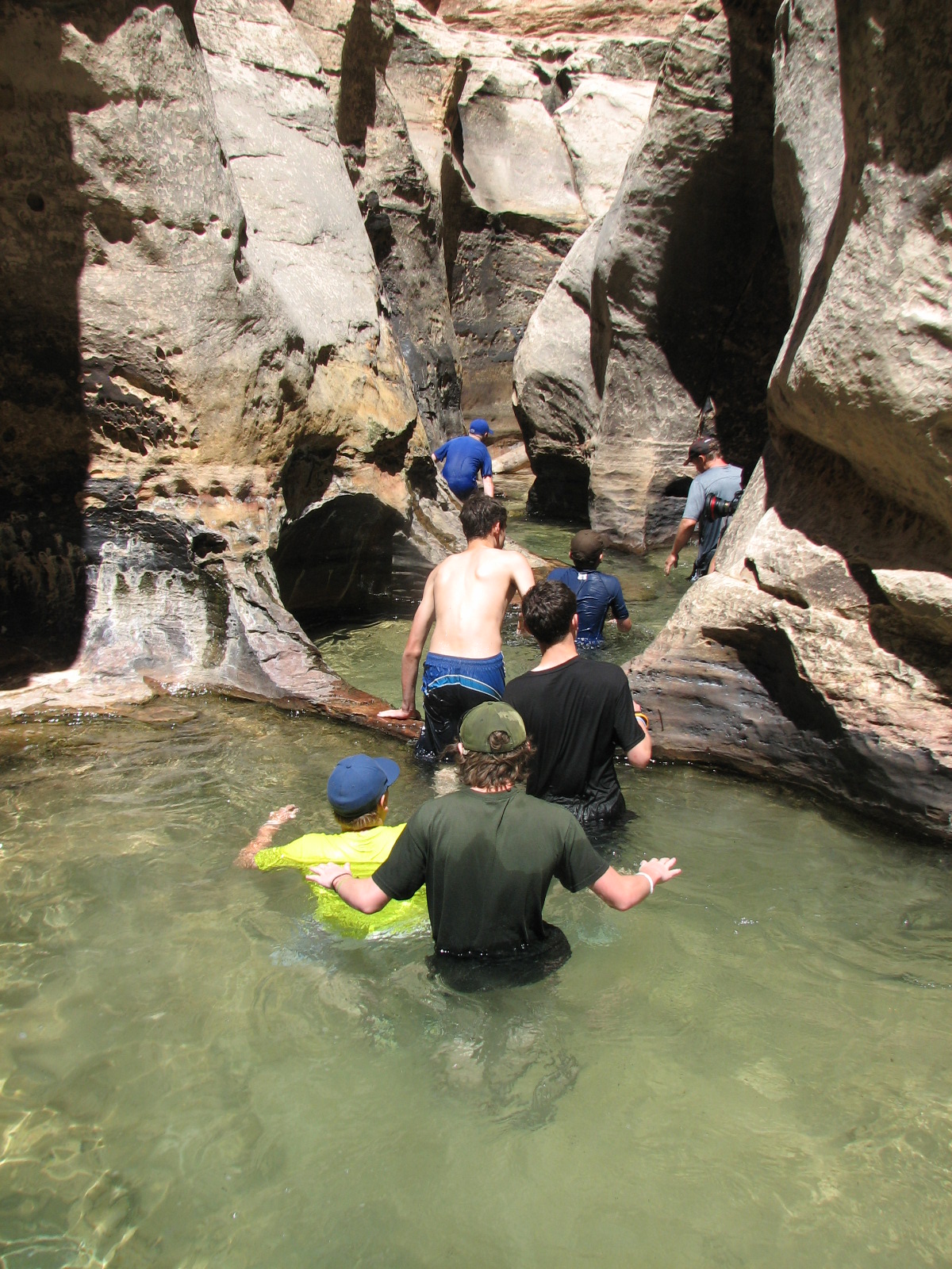
     As you hike up the stream, try to follow the designated trail. Even then, much of the time you will be trudging through the stream or boulder-hopping. In any case, always use care since rocks and boulders may be slippery or loose.


     After roughly two miles, you will start hiking on the slickrock. At this stage, you will see several cascades and waterfalls. The falls can be bypassed on the right. When hiking up the cascades, use caution because they can be extremely slippery due to moss growth. Upstream from the second waterfall is the famous "train track" crack where much of the water flows through a long, narrow crack.

Train Track Crack
     Soon, the canyon will make a sharp right turn and the magnificent Subway formation will become visible. It is a narrow canyon that widens at the bottom creating what looks like a subway tunnel. Once you hike into this section, you will see several small emerald pools you can swim/wade in. If you want to get soaked, continue through these to the Waterfall Room where a 20 foot waterfall cascades down into the pool. This marks the turnaround point since you can't go on without rappelling gear.
The Subway


     Enjoy the scenery from the opposite view as you hike out. You might want to take some time to try out the natural slickrock slides that are present at a few different spots. When you reach the end, the hike back up the 400 foot cliff can be draining, so make sure you leave enough time to get out before dark.

Rating: 5 stars (out of 5)

Things You Should Know: - You must have a permit to hike the Subway, regardless of the direction you travel. Only 80 permits are issued each day in order to keep the area from being destroyed from heavy foot traffic. To obtain a permit, you should apply for one through an advanced lottery system. On-line reservations for each new month (3 months ahead) become available on the 5th day of every month at 10:00 am MT. A few permits are saved for a "Last Minute Drawing." These can be applied for on-line during a window from 7-2 days before the hike (at noon MT).
- After reserving your permit on-line, you must pick up your permit in person the day before (or the day of) your hike at the Zion Canyon or Kolob Canyon Visitor Centers.
- There is no lottery to hike from November-March due to the scarcity of applications. However, hiking during this time frame requires cold water protective gear.
- Hiking in April is more challenging due to spring run-off.
- Do not hike the canyon if there is rain due to the flash flood potential. It is difficult to lose a hard-earned permit, but it is better than losing your life.
- Camping is not permitted in the Left Fork.
- Only experienced hikers should hike the Subway! Regardless, it is always a good idea to hike with a first aid kit since there is always the chance of cuts and bruises due to loose rocks or slippery stones. It is also a good idea to carry some moleskin to take care of blisters.
- There are many "false trails" that have been made by careless hikers. If a trail is "blocked off" by rocks or logs, it isn't the right trail.
- Regardless of how experienced the hikers are, they should be accompanied by someone who knows the route or obtain a detailed route description. Even then, it is easy to stray off the trail. Some friends of mine hiked from the top down and took a wrong turn that took them to a cliff which was taller than their rope. Since it was getting late, they were compelled to go down it anyway so as not to be caught in the canyon after dark. One of them suffered severe rope burns on his hands and another fell about ten feet and hit his head. Luckily no one was injured worse. The moral of the story is that everyone in the group should be familiar with the landmarks of the trail so as to decrease the chances of you taking a wrong turn.

Nearby: Angels Landing, Birch Creek Falls, Pioneer Park (St. George), Snow Canyon St. Park

Monday, April 3, 2017

Spotlight: Zion National Park - Angels Landing

Spotlight: Imagine hiking along a path about 10 feet wide, with a thousand foot drop on either side. Now imagine that there aren't any railings keeping you away from the edge. Welcome to Angels Landing. This isn't a hike for the faint of heart, young children, or anyone who suffers from a fear of heights, dizziness, or other health issues. For all others, Angels Landing offers one of the most stunning vistas in the country, if not the world. It got its name in 1916 when explorer Frederick Fisher proclaimed that only an angel could land on it. In any case, the feeling you get staring down at the Virgin River 1,500 feet below is indescribable.
the objective


Location: Angels Landing is located inside Zion National Park about 41 miles east of St. George, Utah. The trail head is located near the Grotto picnic area at shuttle stop #6.

Cost: $30/private vehicle for a week-long pass. Commercial vehicles are charged $15/person. For additional information on fees, click here.

Time: Hiking Angels Landing takes about 4-6 hours. The trail can be accessed via the park shuttle anytime from April - October, or by private vehicle the remainder of the year.

Description: This five-mile hike is strenuous due to its steepness (1,488 feet of elevation gain), however the trail is well maintained and the first two miles are paved. If it is sunny, there is very little shade; if it is wet, stormy, windy, or icy, you shouldn't hike it because slipping can result in death. That said, I hope I didn't scare you off, because this is one of the most spectacular hikes in the world.
     From the Grotto picnic area, you cross the Zion Canyon Road. From there, you cross the footbridge and turn right and follow the West Rim Trail.  and follow a series of switchbacks that hug the canyon wall offering nice views of the valley. This section offers little reprieve from the sun, so make sure you have plenty of water and sunscreen.

     Refrigerator Canyon is the shadiest section of the trail. It is often cooled further by a brisk breeze. The grade isn't as steep here either, so enjoy the respite while you can.
sandstone caves in Refrigerator Canyon
     From there, the path goes up a steep set of 21 short switchbacks known as Walter's Wiggles. You may need to take frequent breathers while climbing this section.
     The Wiggles take you up to Scout Lookout, a broad sandy area that forms a saddle between the West Rim Trail and the Angels Landing Trail. Many hikers reach this point and decide that it is far enough - and that's perfectly okay. You get an awesome view without having to cross the chasm to Angels Landing.
View of the trail from Scout Lookout
 

     The last half mile, the Angels Landing Trail, takes you across a narrow sandstone ridge with sheer drops on either side (one side is an 800 ft. drop, the other 1,200 ft.). Strong iron chains and guardrails are anchored along certain sections of the fin as an added layer of protection as you climb to the knoll on the top of the monolith known as Angels Landing. The 360 degree view of the park from this vantage point is simply awesome.

narrowest spot

on top of the world
Rating: 5 stars (out of 5)

Things You Should Know: - This hike isn't suited for young children. Hikers should be well coached on proper trail etiquette and the dangers of showing off or playing pranks.
- Spring and autumn are the best times to do this hike. Summer is hot and crowded. Winter can be treacherous because of weather.
- The chipmunks are pretty aggressive and will steal your snacks if you set them down for a few seconds.
- Restrooms are available at the trail head and at Scout's Lookout.
-  Academic waivers for Zion NP can be granted for educational groups pending application approval.

Nearby: The Virgin Narrows hike, The Subway hike, Kolob Canyons, Cedar Breaks NM