Sunday, April 29, 2018

Spotlight: Colorado - Silverton Old One Hundred Mine Tour

Spotlight: In the spring of 1872 the Neigold brothers arrived from Germany and staked their claim on the "Number Seven" vein. Reinhard, Gustave and Otto Neigold organized the Midland Mining Company and spent 30 years prospecting the veins on Galena Mountain. In 1904, the Midland Mining properties were sold to the Old Hundred Mining Company. By 1906, gold bars were being shipped to the Denver Mint. By 1908 the good gold was "mined out" and the financial panic of 1907 dried up sources of new capital. The Old Hundred Mining Company never made a profit on the ore it mined, and later defaulted on its debt to the Neigolds who got the now abandoned property back. The brothers tried to sell the mine but eventually lost it due to unpaid back taxes. During the 1930's, new owners worked the mine sporadically but still unprofitably. By 1973, the mine was finally abandoned. It remained so until it was opened up to tours.
Galena Mountain
Location: The Old Hundred Gold Mine is located at 721 County Road 4A, Silverton, CO. It took longer to get there than we expected because of road work and its location outside of town, but we got there just in time for the last tour.

Cost: $18.95/adult; $9.95/child (5-12); $16.95/senior (60+)

Time: From early May to early October, the Old Hundred Gold mine is open for tours. Tours start at 10:00 am with the last tour at 4:00. The tour takes one hour, so plan on spending about 90 minutes there.

Description: The tour takes you 1/3 of a mile into the heart of the Galena Mountain. First you take an old open mining cart into the heart of the mine. Then you get out and walk through the tunnels where the miners worked. You get an up close view of vein of colorful crystals with demonstrations of how mining work was done while your tour guide explains how the equipment was used back in the early-mid 1900's as well as other interesting tidbits on mining life - including a view of an original "port-o-potty".


old elevator


Mining Car port-o-potty
     Before or after the tour, visitors can try out their hand at panning for gold (or silver or copper) in the sluice box. Panning is "free" with a paid tour and you may keep any metal you find.

Rating: 2 1/2 stars (out of 5); the tour was interesting, but not worth the price of admission.

Things You Should Know: - The "Million Dollar Highway" from Durango to Ourey is quite steep with steep drop-offs, so if steep mountainous roads scare you, you won't like this one.
- Give yourself extra time to get there because of low speeds and road conditions.
- Our tour guide was a no-nonsense ex-miner who told it like it was. If children are getting a little careless, he makes sure the parents set them straight.
- If you are visiting Silverton via train, there is a Train Connection Shuttle.
- Temperature inside the mine is a constant 48 degrees, so a jacket or sweater is recommended.
- You wear the rain slicker for protection from the water which you will probably encounter and a helmet to protect you from falling rock which you probably won't encounter.

Nearby: Durango & Silverton Narrow Guage Railroad Train, Ouray Hot Springs, Cascade Falls Park, The Black Canyon of the Gunnison NP

Sunday, April 22, 2018

Spotlight: Colorado - Black Canyon of the Gunnison NP

Spotlight: The Black Canyon of the Gunnison National Park was established in 1999 and protects 12 miles of the Gunnison River. The Gunnison River drops an average of 34 feet per mile, making it the 5th steepest mountain descent in North America. The steepness of the canyon casts most of its walls in shadow and making them appear black - hence its name. In fact, much of the canyon only receives 33 minutes of direct sunshine each day. The canyon is home to a wide variety of animals including pronghorn, black bear, coyote, muskrat, cougar, raccoon, beaver, elk, otter, bobcat, mule deer, eagle, hawk, falcon, etc.


Location: The Black Canyon of the Gunnison is located in western Colorado near Montrose. It is accessible from I-50.

Cost: $10/person or $20/vehicle; entrance fees are waived for holders of the America the Beautiful passes

Time: Most of the park is closed during the winter except the South Rim Road to the Visitors Center. Other roads usually open from mid-April through mid-November, depending on weather. The Visitors Center hours are from: 8:00 am to 5:00 pm during the spring and fall, 9am - 4 pm in winter, and 8am - 6 pm in summer. Plan on staying for 3-6 hours depending on which activities you plan on doing.

Description: The most common way to see the Black Canyon of the Gunnison is by driving along the scenic drives and getting out at the viewpoints. The South Rim Drive is 7 miles with 12 overlooks and takes about 2-3 hours to drive (including stopping at the viewpoints). The North Rim is reached by taking a gravel road from the east end of Crawford State Park. The North Rim Road traverses along nearly vertical canyon walls to 6 overlooks. This route will require another 2-3 hours. The East Portal Road drops down into the canyon along a very steep road (16% grades) with hairpin turns to the Gunnison River. At the bottom, you can access the Curecanti National Recreation Area where visitors can camp, picnic and fish.


     However, to see the best views, you need to get out and hike along the trails that lead to even better viewpoints. Most of these trails are rated "moderate" and are about a mile in length (round trip). Of course there are also a couple of more extensive trails, such as the North Vista Trail (7 miles/strenuous).


     Other popular activities include: rafting, kayaking, rock climbing, wildlife watching and horseback riding. Winter activities include cross-country skiing, snowshoe trekking and winter backcountry camping.

Rating: 4 stars (out of 5)

Things You Should Know: - Many trails pass by steep dropoffs, so keep a close eye on children.
- The South Rim entrance is about 15 miles east of Montrose. The North Rim Entrance is 11 miles south of Crawford.
- Campgrounds are located at the North Rim, South Rim and East Portal.
- Vehicles over 22 feet in length (including trailers) are prohibited to go down the East Portal Road.
- Honestly, the pictures don't do the park justice.

Nearby: Needle Rock, Baldridge Park, Dominguez-Escalante Nat'l Conservation Area, Grand Mesa National Forest

Sunday, April 15, 2018

Spotlight: Colorado Springs - Pikes Peak

Spotlight: At 14,115 feet, Pikes Peaks isn't the tallest mountain in the country - or even in the state of Colorado. It is, however, one of the most famous mountains in the country, as advertised in its nickname - America's Mountain. Why is it so famous? Probably because it is the highest peak of the southern Front Range of the Rocky Mountains, which means it was the first truly majestic mountain explorers encountered after crossing the Great Plains. After thousands of miles of flat prairie, the sight of Pikes Peak was truly amazing. Also, when gold was discovered in the area, prospectors set out for the area bearing signs declaring "Pike's Peak or Bust." The mountain was named after explorer Zebulon Pike, who unsuccessfully tried to climb to the summit.


     In the summer of 1893, Katharine Lee Bates, and English professor at Wellesley College was in Colorado Springs to teach a summer session at Colorado College. While there, she and a group of professors took a carriage ride to the top of Pikes Peak. The view from the top was so awe-inspiring that Bates penned the words to the song "America the Beautiful" that very night.

Location: Pikes Peak is just west of Colorado Springs and can be accessed from Pikes Peak Highway. The Gateway entrance is at 5089 Pikes Peak Hwy, Cascade, CO.

Cost: Pikes Peak Highway is a toll road: $15/adult (May-November), $10/adult (December-April); $5/child (ages 6-15); $50/carload (up to 5) from May-November or $35/carload from December-April

Time: Pikes Peak is open year round - weather permitting. It is closed for Race Day in June. Hours: 9am-5pm (October-May), 7:30 am - 8 pm (June - Aug), 7:30-7 (September). Hours may change due to weather or events. Plan on spending from 3-6 hours depending on your activities.

Description: When we went to Pikes Peak, we reached the top via the Manitou and Pikes Peak Cog Railway - the world's highest cog railroad. Although my oldest daughter and I have hiked to mountain peaks before, this was the perfect way for my wife and youngest daughter to experience the joy of a mountain peak for themselves. We sat comfortably and watched the alpine scenery pass while our guide told us about the highlights along the way. Unfortunately, after 125 years of service, the railway will be closed for the 2018 season as the company assesses how to update their equipment. It may or may not open again in 2019.


Colorado "gravel"
     Of course there are other alternatives for reaching the top. The most common is to drive the 19-mile highway at your own leisure. Of course there are people who prefer to hike or bike the mountain (either one way or both) as well as some certifiably crazy individuals who run to the top and back. The most popular hiking trail is the 13-mile Barr Trail, which starts in Manitou Springs and approaches the summit from the east. The trail is also the site of the annual Pikes Peak Marathon. There are also a number of tour groups who organize excursions up the mountain.
     At the top, the Summit House sells hot beverages and donuts as well as any number of souvenirs. It also provides some shelter from the wind and cold. Keep your eye out for yellow-bellied marmots and other wildlife which populate the area.


Rating: 4 1/2 stars (out of 5)

Things You Should Know: - If you are not used to high altitudes, take it slow and drink plenty of fluids. If you start to feel headaches, dizziness or nausea, you are probably suffering from altitude sickness. The best cure is to start heading down the mountain.
- Every year, Pikes Peak Highway hosts the annual Pikes Peak International Hill Climb (a motor race) as well as a couple of bike races. The highway is closed to other traffic on race days.
- If you drive to the top of Pikes Peak, make sure you have at least 1/2 tank of gas. Check your brakes before you go. Also, use low gears so that you don't wear out your brakes.
- The peak is about 30 degrees colder than it is at the base of the mountain any given day.

- For up-to-date weather and road conditions, call 719-385-7325, then press "1" twice.

Nearby: Manitou Incline, Cave of the Winds Mountain Park, Broadmoor Seven Falls, Garden of the Gods, and more

Sunday, April 8, 2018

Spotlight: Colorado Springs - Garden of the Gods

Spotlight: The Garden of the Gods is spectacular! When I did my Top 10 list of city parks I've been to, I ranked it #1. Why did it rank so high? First, it is one of the most beautiful parks I've been to. Second, it offers a plethora of activities including: hiking, biking, rock climbing, horseback riding, etc. Third, it has some fascinating rock formations.
     The land known as the Garden of the Gods was purchased in 1879 by Charles Elliott Perkins. Before his death, Perkins expressed his desire for the land to be donated to the city of Colorado Springs to be used as a park. In 1909, after his death, Perkins' children donated the land to the city of Colorado Springs with the stipulation that it "remain free to the entire world." Although it isn't run by the National Parks Service, it carries the designation of National Natural Landmark. The 1,367 acre park attracts about 2 million visitors annually from all 50 states and 60 countries.


Location: The Garden of the Gods is located at 1805 N 30th Street on the outskirts of Colorado Springs.

Cost: The park and Visitor Center are both free. Guided jeep, segway and trolley tours are available for a price. Check out the official website for prices.

Time: Open 5:00 am - 11:00 pm (May - October) or 5 am - 9 pm (November - April); Visitor Center hours are: 8 am - 7 pm (Memorial Day - Labor Day), 9-5 the rest of the year. Plan on spending 2-6 hours.

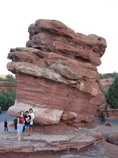
Description: The Garden of the Gods has 15 miles of hiking trails ranging from easy to moderate. Many are paved and are designed to provide access to the parks most beautiful rock formations including the Kissing Camels, Siamese Twins, Steamboat Rock, Balanced Rock, the Scotsman, and more. The park can also be explored by bicycle, segway, jeep, trolley and horse.
Kissing Camels

Siamese Twins

Balanced Rock

Steamboat Rock


rock climbing


Rating: 5 stars (out of 5)

Things You Should Know: - Pets are allowed (with a leash) throughout the park; but owners are responsible for cleaning up their waste.
- Rock climbing permit and safety gear are required for any rock climbing activites.
- Camping is not permitted in the park, but there are several official campsites nearby.
- The speed limit throughout the park is 20 MPH.
- A free 30 minute guided nature walk departs from the North Main parking lot daily at 10 am and 2 pm (weather permitting).
- In 2018, the Visitor and Nature Center presented their Gateway Adventure Series - a variety of monthly presentations, classes and guided hikes led by naturalists and historians for $5 per person.

Nearby: Rock Ledge Ranch Historic Site, Red Rock Canyon, US Air Force Academy Airfield, Pike's Peak Cog Railway